
by Cara Lewis | Jun 13, 2023 | News
🚴♂️ WHEELIE BIG RIDE 🚴♂️
Ludlow – Haydock Race Course – 110 miles.
After a stormy evening in Ludlow, we thought the air would have cleared and made for a cooler start, but no, it was still warm to start. Coming out of Ludlow we had a slight medical challenge, Kevin’s Achilles Tendons nearly popped, every pedal stroke was agony! But though this was a medical issue, it was potentially self-inflicted, by not setting up the bike seat at the right height for the previous 300 miles, dropping the seat a little made a huge difference and the rolling hills could continue. (Some say this was a easy error to make, others would say he was a fool for taking 300 miles to work this out…)
The first stop was to be at a pub for coffees at Long Water, but we found out this was closed, so it was a pit stop in the car park – where Dave our support team managed to put some refreshments out…
Puncture Repair Time
Then onward onto Nantwich, and the day was hotting up….just as we were reaching Nantwich, we suffered out first puncture…which tested our preparation of spare parts, and we were back on the road again in no time!
Nantwich was a very much appreciated stop, once again Dave did a great job in finding a suitable lunch venue, with some great food!
After lunch, it felt like heading back into the furnace…the hottest day so far…the only saving grace was the lack of hills, but it was definitely a sapping section of the ride, one nice part was that we were hit by a rather large rain shower which made for a refreshing end of the ride.
To finish off the day, we managed a swim in the hotel pool which was a surprise, but a welcome cool down.
‘Richard of the Day’ goes to….yet to be decided….we will potentially collate a few, but I am sure you will have a guess who is leading the nominations.
by Cara Lewis | Jun 12, 2023 | News
 So after a lovely run down into Bath on Day 2, we had a delightful early morning climb back out of the city! Well, that was certainly one way to get the legs loosened off and the blood pumping again!
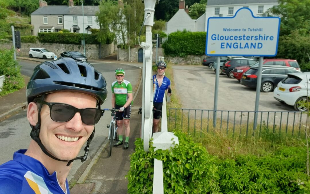
We quickly ticked off another two counties – Wiltshire, very VERY closely followed by South Gloucestershire and made our way through some delightful wee villages en route to our first coffee stop just short of the Severn Bridge.
 At which point…the Richard of the Day award was promptly won by none other than our Kenny again! On leaving the coffee stop he got “attacked” by a tree which nicked his glasses (the tree was feared of both Kevin and Stuart and left them alone) meaning he got split up from the other two. On realising Kevin and Stuart stopped on the bridge to allow Kenny to catch up. Cue a call from Kenny informing them he was lost (within 400m of the restart point) and when told the others were waiting on the bridge, Kenny asked “What bridge”? The answer given cannot be published here…
Red = Start Blue = Kevin & Stuart. Where’s Kenny?!

Once regrouped the team continued over the Severn Bridge into Wales annnnd then back out again shortly after, heading through the Wye valley and Forest of Dean. One of the three countries of Great Britain ticked off! Further on through the Wye valley we came across Kevin’s best man, Ander and lovely wife Jo and wee boy Max with their Wheelie Big Ride support sign. We were very kindly offered lunch at their house which the hungry riders jumped at. Slight catch, it was up a HUGE hill! But we will do anything for lunch!
 Fraser the legend
At least what goes up has to come down so we enjoyed the downhill and rest of the journey through the very scenic and picturesque Wye Valley. After a much needed coffee stop at Leominster (the only coffee shop in town which was still open was sniffed out by Dave, and it was smashing, top marks!) we continued on to our stop for the evening at Ludlow. And what a place to stop, Ludlow looked amazing and will definitely be worth a visit when we’ve got more time! But we had to get on to the hotel where we met Kevin’s family – mum, dad, sister, brother-in-law and the main man Fraser who is the inspiration behind this trip for Kevin. A fantastic evening followed with great company and food!
by Cara Lewis | Jun 12, 2023 | News
🚴♂️ WHEELIE BIG RIDE: DAY 2 🚴♂️
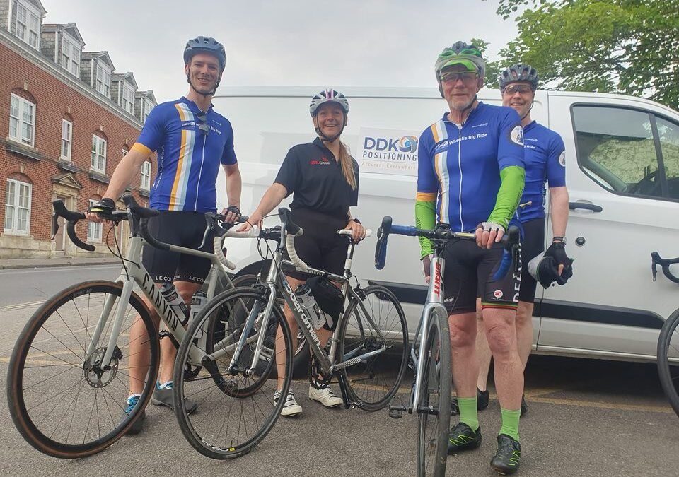
The updates and pics have been flying in over the weekend! Let’s check out what the trio have to say about their second day…and their visit from Sally Dale from our partner NSSLGlobal!
🚴♂️ Starting Oakhampton, the lovely Sally Dale from our partner NSSLGlobal joined us for the first leg. It was lovely to catch up, share the journey, and it was a real boost to the team!
🚴♂️ We are getting into the swing of things; the X1 and the antennas were up and running, Dave Inglis was brilliant at setting up all things DDK ready for David Mckay at DDK HQ to track us to accuracies of less than 5cm!
🚴♂️ When we stopped off at Tiverton and Bridge Water, we met some lovely locals who donated to the charities. We can’t thank them enough!
🚴♂️ Climbing Cheddar Gorge was a real highlight of the day, with stunning views easing the pain of the climb.
🚴♂️ A few hours later, we descended to Bath, and the descent was amazing until we realised we had to climb it again the next morning!
🏆 ‘Richard of the Day’ goes to…. Kenny! For forgetting his GoPro at the beginning of the Cheddar Gorge, he turned back to pick it up; on his return…. we found out it ran out of battery! Worthy of a Richard moment for sure – there definitely seems to be a recurring theme here Kenny! 🤣

by Cara Lewis | Jun 12, 2023 | News
🚴♂️ WHEELIE BIG RIDE: DAY 1 🚴♂️
Well, folks, it’s somewhat been a bit of a learning curve for the dynamic trio over the past few days! Let’s check out what they have to say about their first day…
🚴♂️ Cornwall is hella hilly!⛰️ We knew there was a fair amount of elevation to cover but were not prepared for how relentlessly up and down it was.
🚴♂️ Our training ride speed of 25km/h is ambitious! We ended up with a long 12hr day (including cake breaks! 🍰)
🚴♂️ Garmin navigation is pretty good…when followed (more on this below)
🚴♂️ Don’t clasp your hands in front of you when posing for a photo of the back of your tops; it can have unintended consequences!
Overall though, it was a really good day; after the initial push through the weather, the hedgerows of Cornwall thankfully protected us from the majority of the wind!
David Inglis (Bailey) Inglis played a blinder at getting ahead of the “peloton” and snapping us in action 📸. And at the end of the day, we crossed into the “Sally Dale” territory of Devon and rolled into the hotel in Okehampton.
To celebrate all aspects of the challenge, we decided that each day a special shout-out should be made to the biggest doughball of the day…aka the Richard of the Day🏆 Today’s award goes to…Kenneth Anderson for ignoring his Garmin and his two colleagues shouting at him as he went the wrong way, then proceeding to crack on for a good mile before realising he was on his tod!

by Cara Lewis | Apr 17, 2023 | News
LIVERMORE, Calif. – April 17, 2023 – Topcon Positioning Systems announced it has made a strategic investment in DDK Positioning Ltd, an Aberdeen based specialist in GNSS receivers and PPP correction services. DDK Positioning delivers services exclusively over the Iridium® network to provide global precision positioning services that can augment GNSS constellations to significantly enhance their accuracy for critical industrial applications. Terms of the investment are not being disclosed.
“For a number of years, Topcon has been a supplier of core GNSS components to DDK Positioning to deliver their MAX services. With the expansion and growing success of this business, specifically in the Marine sector, a closer cooperation will ensure optimal integration for the highest possible accuracies and performance in the most demanding applications,” according to Ian Stilgoe, VP of Emerging Business at Topcon.
Kevin Gaffney, CEO of DDK Positioning, stated, “This partnership provides an extraordinary opportunity for our two companies to work together in pursuit of our shared ambition — providing a robust, resilient and truly unique GNSS positioning service. We are extremely excited about partnering with Topcon and it’s a great fit for DDK Positioning, not only will it allow us to continue to develop best in class positioning services, we will also be able to continue to grow the company and expand our services globally.”
About DDK Positioning Ltd
DDK Positioning offers truly global, resilient delivery of precise GNSS positioning services to a number of markets, including; Marine and offshore survey & construction and IoT. The Global Navigation Satellite Systems (GNSS) correction solution enables clients to precisely locate and track their assets globally. Furthermore, a positioning accuracy of less than 5cm can be achieved, compared to the standard GPS accuracy of ≈10m. The uninterrupted delivery of the service, along with independent integrity of position, ensures a higher level of confidence in the accuracy of position and is what differentiates the company from our competitors. DDK Positioning was formed in Aberdeen, UK in 2016 and has an exclusive partnership with Iridium.
www.ddkpositioning.com
About Topcon Positioning Group
Topcon Positioning Group, always one step ahead in technology and customer benefits, is an industry leading designer, manufacturer and distributor of precision measurement and workflow solutions for the global construction, geospatial and agriculture markets. Topcon Positioning Group is headquartered in Livermore, California, U.S. (topconpositioning.com, LinkedIn, Twitter, Facebook). Its European head office is in Capelle a/d IJssel, the Netherlands. Topcon Corporation (topcon.com), founded in 1932, is traded on the Tokyo Stock Exchange (7732).
# # #
Press Contacts:
Topcon Positioning Group
Staci Fitzgerald
corpcomm@topcon.com
+1 925-245-8610
DDK Positioning
Cara Lewis, Marketing Manager
clewis@ddkpositioning.com
+44 (0)7720 216073

